
New Delhi, 13 January 2022: Major earthquake events in last 30,000 years resulted in spectacular changes in landscape of the Katrol Hill Fault in the Kachchh region in Gujarat, a study conducted on sediment samples revealed. These surprising geological facts about the seismic history of the fault in the recent geological past necessitate a revised seismic hazard assessment and mitigation strategies in Kachchh Basin, owing to its close proximity to industrial corridor and major settlements, including Bhuj city.
Earthquakes are one of the natural hazards that geologists are still grappling with its complex nature. The complexity is attributed to its widespread occurrence through space and time. Seismicity in Kachchh region is highly complex as it is characterized by multiple seismic sources in the form of several East-West trending fault lines, which release continuously accumulating tectonic stresses at intervals producing earthquakes. Real-time monitoring of earthquakes since the occurrence of devastating 2001 Bhuj earthquake indicate that most of the faults in the region, viz., Kachchh Mainland Fault (KMF), South Wagad Fault (SWF), Gedi Fault (GF), and Island Belt Fault (IBF) are seismically active. However, seismic activity along other faults like the Katrol Hill Fault (KHF) is not apparent, thus making the task of seismic hazard estimation and mitigation in the region a scientifically complex process.
Geologists from the Department of Geology, the Maharaja Sayajirao University of Baroda, Vadodara, have been trying to decode the seismic activity in Kachchh using geological methods. Recent focused studies of this research group led earlier by Prof. L. S. Chamyal and later by Prof. D. M. Maurya on the not so well understood Katrol Hill Fault (KHF) have estimated the length of surface rupture produced by three large magnitude earthquakes during the last ~30,000 years as nearly 21 km. This study was carried out by field mapping and using sophisticated field instruments like Ground Penetrating Radar and laboratory equipments like Scanning Electron Microscope for analyzing sediment samples.
This research published in the journal ‘Engineering Geology’ and ‘Earth Surface Processes and Landforms’ was made possible through high-end scientific equipments funded mainly under the FIST Programme of the Department of Science & Technology, Govt. of India. The equipment, housed in the Department of Geology, The Maharaja Sayajirao University of Baroda, Vadodara, are being actively used for advanced research in geological and allied sciences.
The team of geologists at the university carried high magnification Scanning Electron Microscope (SEM) study of the surface of sediment samples collected along the faultline, which showed features indicative of surface faulting. Based on various fault parameters deduced like length of surface rupture, displacement, and slip rate, the study shows that the Katrol Hill Fault (KHF) has produced high magnitude seismic events during the past ~30,000 years and is, therefore, a credible seismic source capable of generating surface rupture hazard in the Kachchh Basin.
Further, field-based geomorphological studies revealed that the events resulted in spectacular changes in landscape, as evidenced by the disruption and reorganization of the channel of the Gunawari River in the fault zone. It is interesting that these events produced surface rupture, whereas the 2001 Bhuj earthquake (Mw 7.7) did not rupture the surface. The palaeo-earthquakes along the Katrol Hill Fault produced surface rupture probably because they originated at relatively shallow depths. However, these events show a much longer recurrence interval for the KHF on the scale of thousands of years as compared to other seismically active faults in the Kachchh Basin.
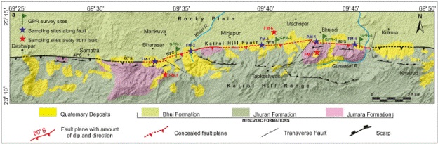
Figure 1: Geological map of the Katrol Hill Fault zone in Kachchh. Red-colored line shows the length of the fault ruptured during the three events in last ~30,000 years.